The trend of natural disasters has increased during the 20th century. In particular, hydrological disasters have acquired big dimension with the beginning of 21st century. According to the international disaster database EM-DAT, regions in European continents paid a huge cost – about 8 billion of Euro between 2010 and 2013 – for general floods. And the future could be worse than the past. Climate change is causing a global sea-level rise, which is expected to accelerate over the 21st century: the predictions foresee a mean sea-level rise of up to 1.35 meter by 2090-2099. This means regular and maybe even permanent flooding of low-lying areas as well as coastal erosion, and an increased risk of catastrophic flooding.
The European Union’s coastline extends for more than 17,000 km across 21 of 28 Member States, and coastal areas cover about 2 million km². According to the European Communities Commission on the flood risk management, the total value of economic assets located within 500 meters of the European coastline was estimated at between 500 and 1,000 billion Euro in 2004. Moreover, several million people live in these areas. Providing new approach to counteract the effect of sea and river level rise has an economic, social, technical and environmental value.
Theseus project
Management of coastal erosion and flooding could not be improvised, it needs a careful planning with sustainable defence strategies. Traditional methods aim to keep the water out of coast, with environmental and socio-economic implications. For the future, Europe needs to assure the coastal economic development together with the inhabitants’ safety, but also sustainability for environment. “Making space for water” will be the future maxim of flood protection.
An integrated answer to the overall problems originates from the THESEUS project, led by an Italian team. THESEUS starts from a high dynamic library, connecting economy, equity, efficiency, sustainability, environment and society, in order to find mitigation measures for European coasts. THESEUS has three main objectives: 1) to assess the risk throughout the European coasts; 2) to elaborate response strategies; 3) to set feasible applications. All these target are developed taking into account best practices and innovative solutions.
THESEUS is an EU-funded project of the 7th framework programme in environmental sub-programme area, covering the period between December 2009 and November 2013. The development of THESEUS has cost 8,534,149 Euro, and Europe has sustained the project with 6,530,000 Euro. THESEUS has been coordinated by Bologna University, but has involved 31 partners from 18 European and extra-communitarian nations.
The project started from the evaluation of present risks in eight different sites and the creation of scenarios for the future, taking into account the economic, demographic and climatic developments of each area. Chosen sites are located near estuary or delta of rivers, where freshwater mixes with open or closed sea water. For each site, data were collected from a huge time lapse and forecasts have been made until year 2100. Data are public and available here. Researchers have completed studies in these areas, combining experiments, numerical models and field observations.
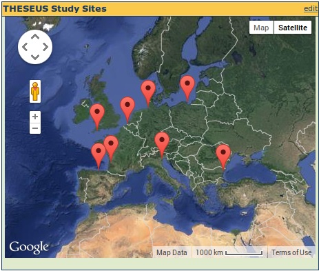
Credits: http://www.theseusproject.eu/wiki/
The second step of the project was the development of innovative hard and soft technologies for mitigation of flooding and coastal erosion hazard. These coastal engineering solutions were assessed in the eight European sites chosen for this study. THESEUS proposed strategies are based on improvement of existing defences (i.e. natural reefs) or on building of new barriers (i.e. littoral drift, floating breakwaters). Also, the role of natural habitats in coastal protection, associated with the costs control, has been estimated. Moreover, the aim of THESEUS project was the development of innovative techniques, such as wave energy converters or artificial reefs. Finally, THESEUS investigated spatial planning policies to minimize the net cost of coastal defence, considering the cost of risk management in comparison with the costs of insurance schemes or land use planning. During this phase, urbanization, insurance programs, evacuation plans and risk communication have been analysed in depth.
The contribution of Italian team was mainly on the development of standard integrated practices, after the estimation of their engineering, environmental and socio-economic effects. It is a multidisciplinary approach: starting from the scientific outcomes of previews studies, the Italian team has created guidelines for defence design, and a free THESEUS software tool for coastal risk assessment and management. The THESEUS Decision Support System (DSS) tool is able to perform an analysis of different variables related to a risk area (social, economic, psychological, engineering, meteorological, ecological aspects) and the effects of climate change. The introduction of all the conditions affecting an area allows the tool to identify the short (2020), medium (2050) and long-term (2080) effects of building or developing within coastal communities. The spatial scale is accurate: it has an order of magnitude from 1 to 100 km. DSS represents a precious mean for decision makers, for communication, training, forecasting and experimentation.
THESEUS has returned 24 multidisciplinary publications, and all documentation is available into the THESEUS open archive. 56 are the end users of DSS tool and guidelines. The next step will be the year 2015, when governments will take adequate and coordinated measures to reduce this flood risk.
Environments and other tools for policy makers
Europe gives
its contribution in the field of climate mitigation and economic impact with
other tools and projects, which will be completed during the next years. IndiSeas developed an integrated method for
marine ecosystems evaluation. Mareframe
will identify indicators of good environment status for seas within 2017, and
the new tool and dataset will support fishery.
For weather forecast and flood prevention will be developed under the Italian
coordination within 2015 DRIHM, with models
and observational archives for the study of severe hydro-meteorological events.
World Water Day has just
been celebrated and the request for water threat control has been forwarded.
The integration of research, modelling and digital platforms could be a
possible answer.